Wednesday, June 26, 2013

A Ridge (Nearly) Too Far - Part 2


Before climbing King George V Mountain (KGVM), I asked the local Inuit population about the best routes to the summit.  The majority of answers and suggestions centered on two possibilities: a skidoo trail on the far left side of the mountain, and going around on the right side near the airport.  When I was climbing up the mountain directly, I was so sure on making it to the top that I forgot about the alternate routes.  Thankfully, my desire to postpone the rest of the hike had brought me to the skidoo trail.  All was not lost.  King George would not get the last laugh at the end of the day.
              
Skidoo trail
The slope that's used as a skidoo trail lies between KGVM and a mountain that's littered with red rocks.  The slope was completely covered in snow, similar to the one I slid down on my boots.  The skidoo tracks looked fresh and went all the way to the top.  I followed the skidoo tracks and reached the top of the slope in 10 minutes. 


I was surprised to see so many red rocks; I had grown use to seeing the colours black and dark brown.  The red rocks reminded me of the geological landscape of Australia.  Nearby stood an odd looking rock formation with a white & brown top.  I photographed it from different angles before continuing on along the rocky edges.  At this elevation, I could clearly see Arctic Bay and Victor Bay.  Taking the phrase 'Living life on the edge' literally, I laid down on a giant protruding red boulder and peaked over the edge.  The drop was straight down.  Gripping my camera tightly, I took a picture of Arctic Bay and the surrounding landscape. 
            
Victor Bay (right of centre).

My original approach that came up short.
There was a cold wind blowing when I arrived at the small opening I was unable to reach several hours before.  Examining the opening more closely reaffirmed my earlier conclusion that climbing it without proper equipment would have been impossible.  If I had made the attempt, I would have slipped and tumbled all the way down the mountain.  I carefully navigated around the opening and continued walking towards the inukshuks I had spotted on my earlier ascent.  I was most interested in the inukshuk that had been built on the edge of a protruding rock.
            
Summit of KGVM
The summit of KGVM is a wide plateau; not completely flat but a plateau nonetheless.  In the middle, the rocks are brown, black, and beige.  The red rocks are along the edges.  With so much open space, I think it would be possible to build a small town on top of King George's head.  A very large & tall beige inukshuk sits on the summit with small blue chords running around it.  Miniature lights are attached to the chords.  My guess is that the inukshuk is lit at Christmas time with the help of a generator. 


By this time, the overcast clouds had returned.  After filming a 360 degree view from the summit, I carefully walked over to the small beige inukshuk that had been built on a large red boulder.  One must use extreme caution because the path to the inukshuk lies between two steep drops.  Upon reaching the Inuit-made structure, I took several pictures and sat down on the ground.  I stayed there for a few minutes, enjoying the view, waving to anyone and everyone in Arctic Bay, and surveying the landscape through my binoculars.  I scrambled back up the path and walked further to the left side and got a clear view of the airport below.  KGVM is a perfect spot to watch aircraft arrive and depart from Arctic Bay.  I was also able to spot the pumping station where the water trucks go to bring water to the people.
            
Arctic Bay Airport
I headed back to the skidoo trail on the far left side of the mountain.  I had thought about descending down the right side of KGVM but it was already late in the day and I didn't want to get home at around midnight.  I followed the skidoo trail down the mountain until it connected to the road to Sewage Lagoon.  I continued on the road leading me through the garbage dump.  The sounds of loud seagulls were gone.  I examined some of the discarded vehicles and objects before replacing my face mask & ski goggles with a black toque & sunglasses.  The temperature was a lot warmer and I didn't want my face to sweat.  With a grin on my face, I looked in the direction of KGVM.  Look whose laughing now, George, I thought.
            

It was a pleasant walk back to my residence with the sun setting in front of me.  The sun would dip just below the mountains and would remain like that until the next morning.  I arrived back at my place at 8pm; my entire day excursion lasted 10 hours!  Despite adding an extra 4 hours to my excursion, I achieved my goal in reaching the summit.  The hike & climb gave me much needed exercise and the views were breathtaking.  Next time, though, I'll have an ice axe and crampons for my boots.


End of A Ridge (Nearly) Too Far Mini-Series.

Sunday, June 23, 2013

A Ridge (Nearly) Too Far - Part 1


Since coming to Arctic Bay in February, there has been one natural landmark that has had my attention for the entire time: King George V Mountain (KGVM).  With an elevation of 492 metres (1,620 feet), you could say it is the centrepiece of the Greater Arctic Bay Area.  It's impossible to miss.  Looking from Arctic Bay, the mountain has two distinct features: rocky slopes that range from gradual to steep, and a crown of jagged rocks at the top.  While I was participating in the spring camp, the view of KGVM from the rear was the complete opposite.  The mountain is connected to other hills similar in height, and the ascent is very gradual, leading to a plateau summit.  I had wanted to hike up KGVM for a long time but was sidetracked by teaching and other priorities.  With the arrival of the Victoria Day weekend, I finally had the chance to conquer the summit. 
            
Power Plant
On the morning of Sunday, May 19, I left my residence at 10am and began walking towards KGVM.  I left my heavy Canada Goose parka behind and wore my lighter skiing parka instead.  I trudged along the mud covered roads in my heavy winter boots while carrying my black backpack.  The bag contained: a face mask, ski goggles, a second pair of gloves, two green apples, and a 'celebratory' chocolate bar for reaching the summit.  While walking through the quiet town of Arctic Bay, I figured the entire excursion would take me about six hours.  My estimate was far from the truth.
            
Heritage Centre
As for snow, much of it had disappeared from the main roads and several mountaintops, revealing mud, discarded garbage, and rocks.  As always, the bay and main waterways connecting to the Northwest Passage were still frozen solid with thick ice and snow.  Cracks would not appear until early June.
            

Road to Nanisivik
After passing the town's power plant and heritage centre, I continued on the road to Nanisivik.  This road also runs through the gas station and by the airport.  Beyond the gas station, a separate road branches off, leading to the town's garbage dump and Sewage Lagoon.  This was my first time travelling the road to Nanisivik during the day.  The gas station area is where one can find warehouses, industrial equipment, snowplows, utility vehicles, and of course, the town's five large gas tanks.  Residents who require fuel for their vehicles must pay first at the Tangmaarvik Inn before filling up.
            
Gas Tanks.
I stopped walking several metres after passing through the gas station area and faced KGVM, like two cowboys about to have a high-noon gun duel.  It's just you and me, I said to myself before moving onward.  I followed the main road before turning left towards the dump.  The dump is the final resting place for everything discarded by locals, including vehicles, sewage tanks, and water tanks.  Garbage collected from households and businesses are placed in a separate large pile, where it is picked and dissected by loud seagulls.  The garbage odour wasn't that bad.  I have been told that the garbage is burned but I'm not sure if that's a regular occurrence.
            

Climbing KGVM - First part of the
ascent is marked in red.
I moved away from the dump and walked towards the first hill I would have to climb.  From here, KGVM looks much bigger and more imposing.  The trek up the hill was easy due to the many rocks I could hold onto.  When I got to the top, I decided to eat one of my apples.  Anticipating strong winds and colder weather, I put on my face mask and ski goggles after consuming the apple.  Taking a deep breath, I proceeded up the second hill that connected to KGVM.  I came across some strange rock formations on my ascent but I didn't encounter any big problems.
            

Upon reaching the top of the second hill, the land smoothed into a gradual arch.  I took a minute to rest my legs, which were burning by this time, and to photograph the views behind me.  I could already see all of Arctic Bay, the dump, Sewage Lagoon, and even Victor Bay.  My imagination conjured up images of the possible views that awaited me at the summit.  Looking at the relatively flat top of the second hill, I also imagined it being possible to host a winter or summer camp, but the rocks would have to be cleared before any tents could be pitched. 
            
Climbing KGVM - Second part of the ascent is marked in red.
I spotted an inukshuk at the other end of the second hill.  I proceeded towards it and photographed it from several angles.  Beyond the inukshuk lay the steep rocky slopes of KGVM.  I took several minutes to look at possible approaches to the summit.  I had to play it safe because I wasn't carrying any professional climbing equipment.  I decided to proceed up the rocky face that was slightly off centre, leading me to a small opening between two tall and jagged rocks at the very top.  After eating my second and last apple, I continued on my trek.
            
The level of difficulty increased relatively quickly because I had to cross an area of smooth slippery snow.  With no rocks to hold onto, I had to search for exposed patches of foliage and hop between them.  From what I can remember, I think I slipped and fell once before making it to the rockier patches.  The higher I climbed, the more I wondered if anyone back in Arctic Bay was watching me?  By this time it was just after lunch and I could hear the sounds of skidoos, and vehicles in the distance.  Looking back, I also watched sewage trucks driving to the lagoon, dumping the waste they had collected from households.
           
I began to encounter some of the same difficulties when I scaled the nameless mountain (aka 'Mount Adrian') during the spring camp: loose rocks.  This forced me to check every rock before grabbing, stepping, and/or moving it.  This slowed my ascent considerably but it was better this way; I was alone and couldn't risk getting injured. 


There were three very large boulders along the final part of the climbing path.  I was glad they were there because they acted as my rest points.  The overcast above me was beginning to clear and by the time I reached the second large rock, there was a clear blue sky.  I stopped to catch my breath and to enjoy the view of the Arctic sun shining down on the Greater Arctic Bay Area.  Looking at my watch, I figured that I could reach the summit by 2:15pm.  With the small opening in sight, I lumbered up even higher . . . only to hit an invisible wall just past the last large rock.          
            
So close yet so far.
Here, there were only two small patches of rocks and most of them were loose.  Beyond that was just a smooth slope of snow that looked solid but slippery.  I tried to get closer but I couldn't get a solid footing on the exposed rocks.  Lacking ice axes for my hands and claws for my boots, there was no way I could scale the last remaining metres to the summit.  Feeling disappointed but not defeated, I decided to look for another way up by moving to the left of the mountain.  I chose this direction because there were a lot of exposed rocks to hold onto.
            
Getting over to the exposed rocks proved to be another challenge because I had to climb down and move across slippery slopes.  The snow up here was still frozen solid; breaking it to get a good footing would be tough.  This forced me to sit down and kick at the snow with my boots.  I would then move from one sitting position to another.  Unfortunately, I wasn't wearing any snow pants because I didn't want the added weight and sweat.  I would have to make due with a cold and wet bottom.  I repeated this process until I reached the rocks.
            
It took me about two hours to go as far left as I could.  Despite slipping and sliding a few times, I was surprised that I wasn't afraid of the high altitude.  Looks like tandem skydiving and completing the CN Tower Edgewalk worked in subsiding my acrophobia.  All the other direct paths I surveyed presented the same problem: they were too risky to climb without the proper equipment.  When I came to this conclusion, I could have sworn I heard King George laughing at me.  It was already past 4pm (6+ hours of hiking) and I had yet to reach the summit.  Feeling dejected, I decided to call it quits.  "I'll be back," I said out loud, putting the mountain on notice.
            

I found a nearby snowy slope that looked perfect for skiing.  I crouched and slid down it using my boots.  The short ride was fast and fun.  Halfway down, I moved off to my right, and walked over to a rock covered hill.  Setting down my backpack, I retrieved my celebratory chocolate bar and opened it.  Well, I guess I could celebrate almost making it to the top.     
            
While munching on the bar, I gazed at the majestic scenery around me.  I'm not sure if it was the chocolate or just the sugar inside, but my brain suddenly began computing a lot faster.  In a few seconds it pointed my head towards something my eyes had glazed over.  My eyes lit up at the discovery.
            
"Oh, I'm not done!  Not even close!"      


To be continued . . .

Thursday, June 13, 2013

Spring Camp - Part 3


My assumption was correct.  The K - 3 students and teachers did have fun at the spring camp on Tuesday afternoon.  Later in the week, those same feelings and comments were expressed by the Grade 5 - 9 students.  Inuujaq School's principal, A. Salam, also participated in the spring camp activities with the K - 3 group.  The spring camp is one of the school's most highly valued activity.  I can see why, because it's a change of scenery (outside of the classroom), and challenges students to use the traditional skills they've learned in school out on the land.  What I also noticed is that the Inuit are not bothered by the very dark face tans they receive from the sun.  And I do mean very dark.
            
With the majority of my students assisting elders at the camp, I chose to postpone teaching new material until the following week.  Instead, I did review work with the students who stayed behind on Wednesday & Thursday (May 15 & 16).    Morning and afternoon recess duties were much quieter and simpler due to so many students attending the spring camp.
            

Friday, May 17 was the last day of the spring camp, and it was reserved for Inuujaq School staff.  While students slept in Friday morning, teachers and school administrators assembled out on the ice in front of the Northern Store, ready for another day trip.  Unlike the previous days, the sky was mostly covered with grey clouds.  And the temperature was a little warmer.  I decided not to wear my snow pants because I didn't want the added weight when hiking up rocky hills.  I did keep them in my backpack just in case the weather got colder.  The mood was festive as everyone sat & stood around the skidoos and qamutiqs, drinking hot beverages and wondering what the day would bring.  After a quick headcount, (between 20 - 30 people, including two students), everyone jumped into a skidoo or qamutiq and the convoy was on its way.  The principal would meet everyone at the camp site later in the morning because he had administrative work to complete.   
             

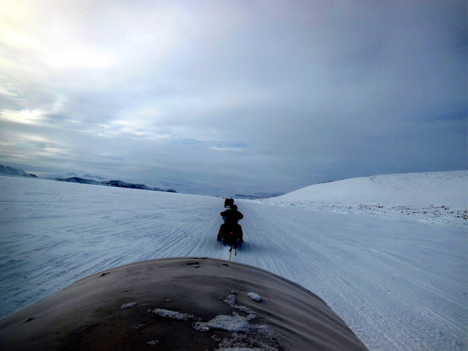
Me inside the luxurious qamutiq.
Picture taken by Ryan, the media/
computer studies teacher.
There was a feeling of deja vu as the convoy followed the same skidoo trails to the camp site.  The scenery was the same even though the sky was cloudy.  That didn't stop me from taking pictures.  The qamutiq I was riding in included a luxurious interior, fully decorated with blue curtains and mattresses.
            
The five white tents were still in place when the convoy arrived at the camp site.  Everyone helped to unload food, equipment, and personal bags off the qamutiqs.  The longest wooden qamutiq was then turned over because the black rubber treads needed to be sharpened and waxed.
            

I tagged along with Sean, Kyle, and Ryan, three Inuujaq School teachers, who decided to hike up a nearby rocky hill line that connected to Holy Cross Point.  We were also joined by an elementary school student whose name I've unfortunately forgotten.  From a distance, the trek looked simple but it turned out to be a challenge.  First, we had to walk across very slippery ice patches and climb over frozen mounds of ice & snow.  These mounds were most likely created by the sea current underneath pushing the frozen ice on top against the shoreline.  Next came the hill climb.  The white snow was very tightly compact and slippery, forcing us to use the rocks as steps.  We eventually made it to the top and were treated to a wonderful 360 degree view of the surrounding area.  The camp site looked very small in the distance.
            

I left my backpack near a very large rock and continued the trek with the teachers.  The hill line is littered with large rocks.  We climbed up one tall rock face, being careful not to slip and fall.  Upon reaching the top, Ryan and I filmed videos of the scenery while Sean, Kyle, and the elementary student descended down to the other side of the hill.  The path they chose was a little steep and contained jagged rocks, but they made it safely down to the bottom.  Several minutes later, Ryan & I arrived at a collection of large boulders, littered with rabbit droppings.  An Arctic hare or family of hares were using these boulders as a home but we didn't see any.  While we continued to take photographs, we spotted the principal arriving at the camp in a rented skidoo. 
            
Sean & Kyle gazing at the spectacular scenery.
The tall hill (background) next to
Holy Cross Point.
Wanting a bigger challenge, I decided to hike to the top of the very tall rocky hill that sat next to Holy Cross Point.  Ryan chose to stay behind.  I continued alone, stepping around and over rocks of many shapes and sizes.  The overall ascent to the top wasn't difficult despite a few spots that required the use of all four limbs.  I was glad I didn't wear my snow pants, otherwise I would have sweat too much.  I raised my fists into the air when I reached the summit.  I filmed a 360 degree short video, capturing the surrounding mountains and the sounds of silence on film.  In the distance, I could see Arctic Bay and the airport.  Towards the entrance to the Northwest Passage, a low formation of clouds was slowly moving in my direction.  A snow storm appeared to be moving in.  I also saw the small outlines of Sean, Kyle, Ryan, and the student walking back to the camp site.  Looking at my watch, I realized it was nearly noon.  I quickly took some more pictures with my camera and slowly made my way back to camp.  I also made sure to pick up my backpack on the way.
            

"Was that you up there?" asked one of the Inuit teachers when I returned from my trek.
            
"Yes, it was," I replied.  "The view from up there is just great."
            
Me staring off into the distance.
Picture also taken by Ryan.
Lunch consisted of caribou stew, eggs, bacon, bread, tea, juice, and hot chocolate.  I ate my lunch in the same tent I slept in on Monday night.  At the moment, it was being used by the male staff as their eating area.  When I entered the tent, they asked me how I enjoyed my trek up to Holy Cross Point.  I replied that the trek was worthwhile and the views were fantastic.  Upon seeing a frying pan full of cooked bacon, I couldn't help but share a news story I had recently read on the Internet.
            
On May 9, an elderly lady in the United States celebrated her 105th birthday, and the local media asked her what was the secret to her longevity.  The Texas woman replied that she ate bacon every day.  To celebrate her birthday, Oscar Meyer gave her a free batch of bacon and let her ride 'shot-bun' in one of their Weinermobiles.       
            
After lunch, I thought about what to do next.  Most teachers were heading out for a seal hunt with the elder hunters but I didn't feel like going for a second round.  Feeling empowered by my hike up to Holy Cross Point, I decided to tackle an even bigger challenge: climbing the tall nameless mountain behind the camp site.  I had just 3 hours to get there and back.  Such a task looked daunting given the size of the mountain and the distances I would have to walk.  But, I believed I could do it given that I had previously hiked up the two smaller hills in front of the mountain.  Once publicly stating my intentions, I asked if any teachers wanted to join me?  Sadly, no one volunteered.  With everyone wishing me luck, I set off on my biggest hike yet in the Arctic Bay Area.
        
Climbing the nameless mountain. Route in Red.
The easiest part of the trek was getting over the two low hills in front of the mountain.  In fact, it felt like I got that portion out of the way fairly quickly.  While listening to roaring skidoos in the distance, I trudged forward, moving onto the mountain itself, whose slope had become steep.  There were plenty of rocks to grab onto but I quickly learned to be very selective because many rocks were loose.  About halfway up, I reached a large stack of rocks that formed a flat top.  Rather than climb up, I worked my way around.  When I got to the flat part, I stopped to catch my breath and to photograph the scenery.  I was surprised by how much I could see.
            
The last part of the hike was climbing the left side of the mountain; this proved to be most challenging because the snow was smooth and there were very little rocks to grab onto.  The smooth snow gave the impression that underneath was solid ice meaning I wouldn't get a secure footing.  However, after taking a few steps, I discovered that it was soft powdered snow, enabling me to sink in my heavy boots for better footing.  Rather than walk up the steep slope, I used my arms and legs, punching & kicking deep into the snow, creating a fresh path up the mountain.  By the time I reached the summit, my black gloves were covered by sticky wet snow.          
            

Spring Camp Site (centre).
I reached the summit at around 1:30pm; my ascent took ninety minutes.  Again, I lifted my fists into the air, like Rocky Balboa, to celebrate & signify my achievement.  I also waved to the very tiny people at the camp below.  I wasn't sure if anyone waved back.  The view was spectacular; I could see Arctic Bay, the airport, the cliffs I had explored in early May, the top of King George V Mountain, and the teachers & elders returning to camp after the seal hunt.  Looking through my binoculars, it didn't look like they caught anything.  I spent around fifteen minutes exploring the summit, photographing the jagged cliffs, the surrounding area, and filming a short video.
            

For the descent, I went back the way I came.  I faced the mountain when I descended the left side.  It was like doing the ascent but in reverse.  I could have slid down but I chose to play it safe.  After clearing that section, it was pretty much smooth sailing.  I still took my time because I wanted to relish in the fact that I had gone higher than anyone had gone during the spring camp.  About halfway, I noticed a convoy of skidoos and qamutiqs leaving the camp site and heading back to Arctic Bay.  The time was 2:30pm.  The tents had been disassembled and staff were leaving earlier than planned.  Before I could begin planning my 11km walk back to Arctic Bay, I was met by an Inuk man on a skidoo; he had been sent to retrieve me.                
            
The Spring Camp is no more . . . until
next year.
The Inuk was one of Rebecca's sons.  She is Inuujaq School's secretary.  I was surprised to see him this far up a rocky hill on a skidoo.  "Us Inuit can do anything with a skidoo," he boasted.  The ride down to the shoreline was quick and fun.  I really need to look at getting a skidoo, I thought.  Rebecca and the last remaining Inuit teachers were waiting for me at the shoreline next to a qamutiq.  All that was left of the camp site were piles of rocks.
            
"Did you have fun up there?" asked Rebecca.
            
"Of course!  I could see everything up there.  Did you see me?"
            
"Definitely," she replied.  "We all could see you clearly.  You looked like a tall black post.  Even the people who went seal hunting could see you when they were driving back.  A few of us even waved to you."
            
On the way back to town, I asked the Inuit teachers if the mountain I climbed had a name.  They said no but added they would call it 'Mount Adrian'  from now on.  I chuckled at the honour but wondered if the name would stick.  In return, the teachers asked me if I had any plans to climb any other mountains.  Looking around, I spotted my next target.
            
"King George," I replied.  "Yeah, King George," I confirmed with a nod.  "This Victoria Day Weekend."            
Arctic Bay and the airport in the distance.
As you probably can tell from all three posts, I definitely enjoyed spring camp.  It was a great way to experience living out on the land with Inuit elders and youth.  But it was also a great way to see the striking Arctic landscape.  The land is vast, picturesque, and untouched.  It makes you feel like you're on a different planet.  Truth be told, there were moments when I thought I was on the planet Hoth, and expecting to see AT-AT walkers and Rebel snow speeders passing by.          
            
I can't wait for next year's spring camp.


End of Spring Camp mini-series.