I rested an entire day
before venturing out on the land on March 28.
This would be a short "Sunday Drive", or, in this case, a
short "(Easter) Monday Drive".
I was going to drive around the small peninsula to the west of Arctic
Bay. The southern part of the peninsula
is where the famed cliffs are located. I
had previously explored a section of the cliffs in 2013, but not the entire
peninsula. For today, it would just be
the perimeter.
I refueled my skidoo and attached my 3-gallon reserve gas can. (Note: Even though Canada has been following the metric system for
many decades, the Inuit here still use imperial terms in common speech when it
comes to gas. I think it's because the
imperial measurements appear more prominently on the red plastic gas cans that
are sold at the Northern & Co-op stores.
I'm not sure if this is the case in the other communities). I packed lightly for this trip and just took
the essentials (shotgun, SPOT, GPS, toilet paper, etc). As always, the weather was perfect - clear
blue & sunny. I wore my helmet in
case the wind picked up or if I fell off my skidoo.
I drove south towards Uluksan Point, a favourite place
for residents to have a picnic and/or bonfire.
There was no human activity when I drove by. I turned right and headed west, driving along
the tall rocky cliffs. They look really
imposing up close. I don't think they're
tall enough for BASE jumping, but they could serve as good launching platforms
for hang gliders and paragliders. The
colours of the cliffs are red and brown, and their appearance has barely
changed in the last three years.
The height of the cliffs dissipates the further west you
drive. By the time I reached the
southwestern tip of the peninsula, the cliffs had turned into hills. I turned north and drove for a few minutes
before stopping to take a photograph.
There are only hills along the northern coast. I couldn't drive as close as I wanted because
the coastline was littered with hard packed ice and those flower-ice formations
I encountered on my drive two days before.
I spotted several small black dots in the distance. Are
they seal hunters or large blocks of shaded ice, I wondered. My question was answered several minutes
later when the dots began to move. Seal
hunters. One of them drove up to greet
me as I stopped my skidoo near the northern tip of the peninsula. The Inuk hunter was one of my former
students. He was out with his father
hunting seals for the Easter Monday community feast happening later in the
afternoon. Unfortunately, they had yet to
find any. I wished him & his dad
good luck, and that I would see him at the feast. He drove off in a hurry to join his father.
I took a break at the northern tip of the peninsula. I ate some crackers and granola bars, then
explored the frozen ice formations along the coast. In the distance, I could hear the sounds of
skidoos circling around known seal holes.
I stopped what I was doing several times to hear gunshots, but there
were none. I hopped on my skidoo and
proceeded to drive south into Victor Bay.
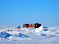
The Greater Arctic Bay area is dotted with cabins built
by the Inuit. Many are located in Victor
Bay. I found one such cabin built by
Piuyuq and her husband. She is the Grade
1 teacher at Inuujaq School. I tried to
find the cabin in April 2014 but was unsuccessful. The cabin is located on the northern tip of
the small peninsula, but on the Victor Bay side. It didn't look like anyone was there so I
just snapped a photo and continued driving south. (The local Inuit have suggested that I build
a cabin of my own. I told them that I
would think about it.)
 |
| Ice Road. |
The drive in Victor Bay suddenly became very smooth and
fast because there was a plowed ice road leading from Piuyuq's cabin, all the
way to the end of the bay. I was told an
ice road to the cabin is plowed every year, enabling vehicles to travel out
onto the ice with ease. I followed the
ice road all the way to the end. I drove
off the ice and followed the road to Arctic Bay like I did during the previous
outing. I was only gone for two hours.
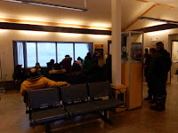
The Easter Monday community feast began at 6pm at the
community hall. The layout of the feast
was done in a traditional manner: three large white sheets in the middle of the
floor for country food, lines of tables at both ends for caribou stew &
bread, and chairs against the walls for people to sit. A team of volunteers dumped and spread out
the country food on the three white sheets while wearing plastic gloves. There was raw arctic char, walrus, and
narwhal. The raw seal meat would be
served from the main stage. The
community hall was packed with people.
 |
| Levi Barnabas speaks. |
Several community members spoke before the feast
began. They thanked the organizers and
hunters for providing the food. An elder
blessed the food with a short prayer and then everyone charged into the centre,
armed with plastic bags and their bare hands.
I stood on a bench at the back and filmed the "rush into the centre". I didn't take any country food because I
still had plenty at home. I saw my
former student somewhere in the crowd but he disappeared before I could ask him
if he caught any of the seals that were being served.
And finally, construction on the new health centre has
resumed after several delays. I'm not
sure what was behind the delays but everyone in the community is glad the
project is proceeding on schedule.


