The
Easter/Spring Break began on April 11th and ended on April 21st, giving
teachers and students a 10-day vacation from school. Many would use the time to go camping,
fishing, hunting, and travel to other communities by skidoo & qamutiq to
visit friends and relatives. The
principal and a southern teacher travelled down south for the break. I had thought about travelling outside the
community but decided to save my money for another time. I would use a few days to clean &
reorganize my classroom, correct class work, and plan lessons. The rest would be spent on rest & relaxation,
and further exploration of the greater Arctic Bay area.
Since
coming to Arctic Bay back in 2013, I have explored King George V Mountain
(KGVM) twice, the cliffs, Victor Bay, and the school's Spring Camp area. The last time I trekked anywhere was in
August of last year, my second time standing on KGVM's head. That was a little over 8 months ago and my
adventure side was craving attention.
After researching on Google Earth, I settled on exploring
the small peninsula to the north of Arctic Bay and just to the left of Victor
Bay. I had never been further north than
Victor Bay and wanted to get a closer look at Admiralty Inlet, and possibly see
the Floe Edge through my binoculars.
The
Floe Edge is where the frozen ice of Admiralty Inlet ends near Cape Crauford
and Lancaster Sound; beyond that is the ocean.
Many people go to the Floe Edge to hunt seals, walruses, bearded
seals, whales, and narwhals. By skidoo,
it takes between 1½ to 3 hours to reach the Floe Edge, depending on weather
& ice conditions. It's another
location on my list of places to visit.
Google Earth made me realize that I would
have to walk 14km both ways. There would
be rocky mountains & hills to traverse and plenty of snow to trudge
through. There was no doubt in my mind
that the trek would be an all-day affair.
Since I would be hiking alone, I needed to be prepared for
anything.
To
combat the cold, my outer layers of defence included: my brand new Canada Goose
Resolute Parka & Tundra Snow Pants, WindRiver boots, neck warmer, hat,
gloves, and sunglasses. If the wind
picked up, I also had a face mask, ski goggles, and a thicker pair of
gloves. My inner layers were not as
thick because I didn't want to carry too much weight; it would only slow me
down. I just made sure to wear driWear undergarments, and sweatpants to contain my sweat.
My
backpack contained my digital camera, binoculars, bandages, some fruits, a
bottle of water, and sunscreen. (It is
possible to get a sunburn in the Arctic).
I also carried with me a small multi-tool, compass, and SPOT Device. The SPOT Device is an essential GPS beacon/transmitter that tracks your location and can send pre-written text
messages to anyone you choose. Most
importantly, it can also send distress calls. If I didn't have it, I wouldn't have gone on
my trek. The last item I carried was my machete - a last line of defence against natural predators (ie. polar
bears).
On
the morning of Monday, April 14th, I stepped out of my house and walked towards
the road to Victor Bay. As always, it
was a clear sunny day with blue skies.
There wasn't much activity in town as I slowly made my way up the
winding road. Wearing the thick Canada
Goose parka and snow pants made me feel like an astronaut. I was enveloped by silence as I reached the
top of the hill where the road becomes level. Here, I turned on my SPOT Device; it would
record and transmit my location to my private SPOT webpage every 5
minutes. After walking past a few
qamutiqs, the road began to dip and the wind started to pick up. Thinking that the wind would get stronger, I
put on my face mask and ski goggles.
With my body fully covered, I truly felt like an astronaut walking on a
cold, desolate, alien planet.
I
stepped off the road and walked across Dead Dog Lake. It's called that because long ago, a dead dog
was found there. I continued walking
over rocks covered in snow, slowly making my way up towards the first mountain
and line of cliffs. It didn't take long
for me to realize that the distance between me and the mountains narrowed very
slowly. One thing you need to remember
in the Arctic is that measuring distances between points of reference with the
naked eye is difficult. Whatever your
estimate, you need to add several more kilometres. I think that's why everything is so
picturesque up here; everything is spread out over vast distances.
I
took a short break about halfway to the first mountain, eating an apple and
orange while sitting on a large boulder.
The wind had dissipated so I removed my face mask and placed it back in
my backpack. I kept my goggles on my
head just in case the wind returned in force.
I laboured on for some time before arriving at the base of the first
mountain. The cliffs and rocky edges
looked similar to the crown of KGVM, except the rocks were redder. After taking several pictures of the rock
formations, I slowly walked up the side, stepping over many red rocks, evoking
images of being on the planet Mars. Upon
reaching the top, I was treated to a wonderful 360-degree view of the
surrounding area.
Behind
me I could see KGVM, Victor Bay, and many cabins built by the Inuit. To my right, on the other side of the bay,
were more cone-shaped mountains with just a few brown spots. To my left, the mountain was more of a
plateau, connected to another mountain ahead of me. I continued walking along the cliffs,
stopping often to get a good look at the steep rocky gorges. I was careful not to fall over the edges
while I took pictures. After some time,
I came across a very large inukshuk overlooking the entrance to Victor
Bay. Down below, a skidoo trail wound
its way along the shoreline, leading further north. I passed two more inukshuks before the
plateau began to dip. I could see there
was still some distance left to walk. I
filmed a 360-degree panorama of the area and finished my last apple and orange.
 |
| Almost there. |
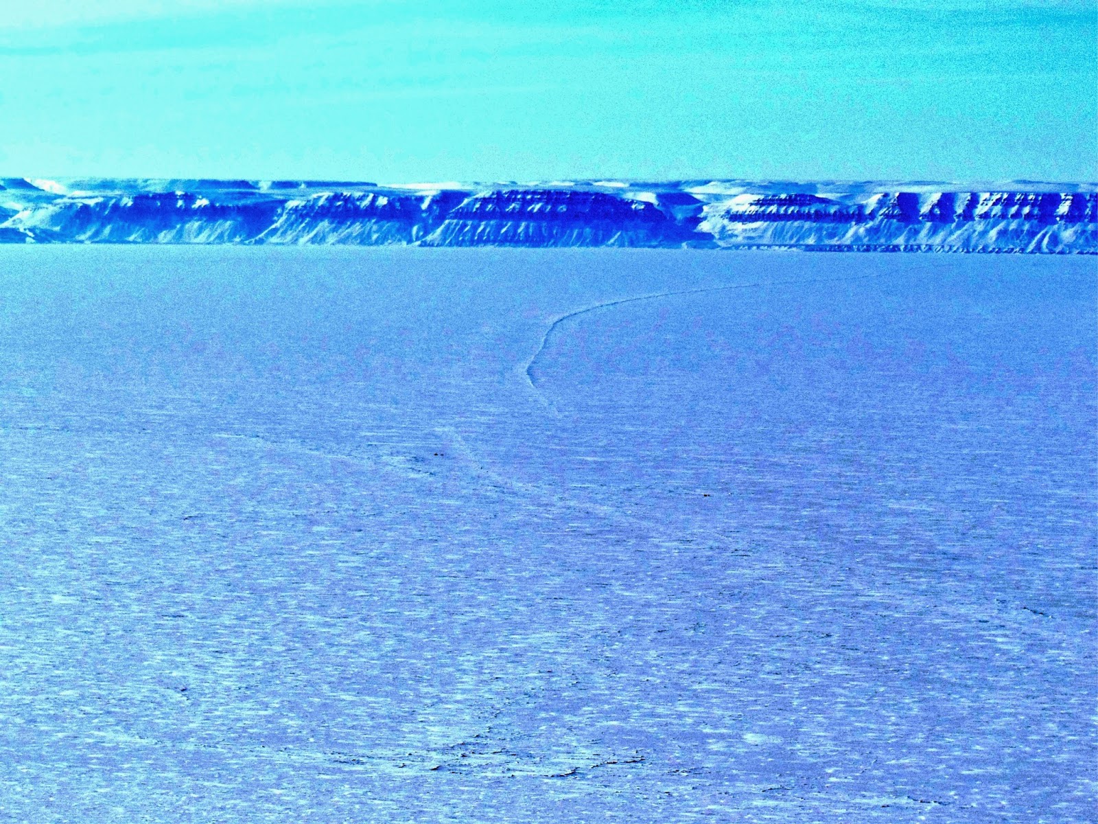
About
halfway to my final destination, I passed an impressive looking mountain on my
left, with slopping hills and a distinct rock formation in its centre. My final
destination was a lone pile of rocks, sitting at the foot of a drop. Admiralty Inlet, completely frozen over,
extended in both directions. From where
I was standing, I could see no icebergs and the ice appeared relatively smooth. I tried to spot the floe edge to my right but
I couldn't see it through my binoculars.
There was still about two kilometres left for me to reach the northern
shoreline of the peninsula but I chose not to proceed because it was already 3:30pm
and my legs were tired. It had taken me
five hours to hike 14km.
 |
| Final Destination |
I
took off my parka and used it as a mat to sit on. I had worked up such a sweat that the gentle
cold Arctic wind was refreshing.
As I drank from my water bottle, I watched two Inuks travelling out in the
middle of Admiralty Inlet. They looked
like tiny black ants. One was driving a
skidoo & pulling a qamutiq while the other was on an ATV. I think they were seal hunting. Suddenly, I could hear a low rumbling sound
in the distance. At first I thought my
ears were playing tricks on me but after much concentration, I spotted a black
speck in the sky. It was a First Air
plane, most likely flying from Resolute. I watched it slowly descend towards Arctic Bay, wondering if anyone on board could see me. I was surprised when I heard the sound of the plane landing at the airport, 18 kilometres behind me.
 |
| Once you're past that, it's smooth sailing. |
At
4pm I put on my parka, gathered my belongings and began the long walk back to
Arctic Bay. The first major hurdle was
to walk back up to the high plateau, some 3km away. From where I was standing, it looked more
like the peak of a mountain.
Nevertheless, I proceeded with the task.
Once you're past that, it's smooth
sailing, I reminded myself. The walk
began on the right foot (pun intended) and I managed to cover a lot of distance
in a short amount of time. However, once
the land started to slope up, it became more of a challenge. I had to stop every 10 minutes to give my legs
a rest. It took me an hour to reach the high
plateau.
Walking
along the cliff edges of the plateau was a lot easier on my legs but I still
had to take several 5 - 10 minutes breaks.
I probably should have stopped and rested for a good 30 - 45 minutes but
I was aiming to be home by 8pm. By the
time I reached the rocky red slope of the first mountain I climbed in the
morning, the time was just after 6pm. My
feet and legs were aching and the sun was starting to set. To take the pressure off, I forged a path
where I could slide down the hill and only walk a few steps here and
there. With the rocky slopes behind me,
my legs felt too tired to walk up hill.
Aiming for downhill slopes, I walked towards Victor Bay, using the Inuit
cabins as my points of reference. If my legs give out, at least there will be
people nearby to help me. All I have to
do is get to the road and I'll be fine.
I
took a twenty minute break in a large trench, carved by running water from
melted snow during the summer months. Looking
at my watch, I knew I wouldn't make it home by 8pm. I now set my sights on 9pm. You
really know how to push your feet & legs to the limit, my mind quipped. I soldiered on, putting one foot in front of
the other, and watched as the cabins in the distance became bigger. I felt a little relieved when I passed the
first Inuit cabin; I was no longer in the "middle of nowhere." I walked past two more before coming upon a
skidoo trail leading to the road to Victor Bay.
Alright, I reassured myself, now things should be easier. I sat up against a snow bank and
reminisced about what I had accomplished up until that point. I had walked more than half the length of a
marathon.
Standing
again for the umpteenth time, I walked towards the main road, wondering if I
would meet anyone. Since it was Spring
Break, I assumed many people would be out on the land or residing at their
cabins. My thoughts were interrupted by
the sound of a skidoo pulling up behind me.
I stopped and noticed that it was Koonerk, one of Inuujaq School's custodians,
and the one who sang Happy Birthday to me back in October. His wife Piuyuq teaches Grade 4 and is the de
facto vice-principal of Inuujaq School.
I didn't hesitate when he offered me a ride back into town. He dropped me off at my place at 8:30pm. I thanked him and we shook
hands.
Overall,
my day-hike was a success but it showed my body's limitations. I didn't trek the full 28km but I'm glad I
didn't because I would have been crawling by the end. Or worse, forced to spend a night out on the
land with no food because my legs called it quits. The whole excursion took 10 hours. Next time I'll leave earlier, bring more
food, and pay someone to give me a lift to Dead Dog Lake at the beginning. Surprisingly, and thankfully, I didn't see
any Arctic wildlife. I was hoping to at
least see an Arctic hare but had no such luck.
On
another note, the annual Nunavut Quest dog sled race began on April 24th. This year the long distance race is from Igloolik
to Pond Inlet, a distance of 395 kilometres.
Last year, the race was from Arctic Bay to Igloolik. No word yet on the winners but the race
should be finished by this weekend.


No comments:
Post a Comment