 |
| The Plan. |
My
skidoo was fully functional by the Victoria Day Weekend. I paid a local Inuk mechanic to clean the
engine, replace several engine parts, and add several extra parts I bought on
the internet. JF installed the new
plastic right hand deflector and rear-view mirror. I was glad to have my skidoo “back in action”
because I missed using it. After three
weeks of waiting, I was more than ready to take her out for a spin.
A
month had already passed since my last outing and the ice was beginning to
melt. I was already hearing from people
that cracks & slush puddles were beginning to form. The snow in town was also melting but at a much
faster rate. The skidoo trails were
disappearing and the roads were turning into mud paths. In another week, I would have to leave my
skidoo out in the bay and walk up two hills to get to my place.
I
cancelled cadets for the Victoria Day Weekend because most families would be
out participating in the annual fishing derby.
The cadets asked me if I was going to participate like I did last
year. (JF & I travelled to
Ikpikituarjuk, a popular fishing lake 105km to the south of the community. Click to (re)read: Part 1, Part 2, Part 3,
& Part 4.) I replied that I was
going to explore another area of land over the long weekend. The cadet corps was already going to
Ikipituarjuk at the end of the month so I didn’t feel like going there
twice. (More about this trip in a future
post).
I already knew where I wanted to go; the valley I passed on my way to the end of Strathcona Sound. I hoped the ice in the
Sound was still thick & solid a month later. I set my day excursion for Saturday, May
20. It took me an hour to get
ready. I packed whatever I needed, from
food to medical supplies to gas for my skidoo.
To avoid excessive sweating, I wore less layers underneath my Canada Goose parka. May is a warmer month
compared to April. I informed my
coworkers about my day excursion and performed my final checks before driving
north towards Victor Bay. (For my final
checks, I make sure I’m carrying a GPS, SPOT device, firearm, and toilet
paper).
 |
| Ice road heading north. |
On a
map, the valley is 53km to the northeast of Arctic Bay, but I would have to
drive about 70km to get to my final destination. On Google Maps, the valley is only 10km in
length, starting from Strathcona Sound, and appears to stop at a point where
the mountains come together. This made
me think that a waterfall may be there.
There was only one way to find out.
I picked a great day to go driving.
The sun was shining and the skies were blue. My skidoo, fresh-out-of-the-garage, was
working smoothly. I drove onto the ice
road and followed it to the co-worker’s cabin.
There road was mostly smooth but there were a few patches of slush.
 |
| My skidoo with Graveyard Point in the background. |
 |
| Sunbathing seal. |
I
drove off the ice road and was about to turn towards Graveyard Point when I
noticed a small black spot on the ice.
It was a seal. I cautiously drove
closer to the seal to get a better view.
I stopped my skidoo and took out my camera. I photographed the animal before driving a
little closer. There were actually two
seals sunbathing and they disappeared down a seal hole when they heard the
skidoo engine. I briefly inspected the
seal holes and then continued driving.
 |
| Seal holes. |
 |
| Ice "minefield". (Bottom of picture). |
I
left Victor Bay and continued driving north towards Cape Strathcona. My plan was to turn right upon reaching the
Cape and then follow the coastline until I reached the valley. I kept to the left, not wanting to enter the
same “minefield” that caused my skidoo to tip over in April. The further I drove, the more it looked like
the “minefield” stretched all the way to Cape Strathcona. In the end, I turned around and headed back
the way I came, but towards Graveyard Point.
I may have wasted some gas, but I still have two red gas cans full of
fuel. And yes, they were securely
attached to the skidoo.
I
didn’t have to drive all the way to Graveyard Point. Instead, I was able to enter Strathcona Sound
by driving ride down the middle of the frozen passageway. I suppose that was risky because I was the
furthest away from land in all directions.
Thankfully, the ice was still thick.
I drove onward, slowly steering my skidoo to the left. The ice became smoother, enabling me to
increase my speed. Eventually, I passed
Nanisivik on my right side. I could just
barely make out the buildings on the other side. There weren’t any cracks in the ice until I
passed Nanisivik. The cracks were small
but I still took notice.
 |
| Entrance. |
The
entrance to the valley appeared on my left.
A very tall & jagged looking mountain appeared in front of me. I drove just a few feet into the valley and
stopped my skidoo. There were large
patches of clear ice stretching from one end to the other. I walked around for a few minutes and
mentally mapped out a route for my skidoo.
I didn’t want to drive onto a patch of ice and then spend the rest of
the day spinning in circles. I passed
the large ice patches and saw that most of the brown land in the valley was
exposed. The only snow and ice that was
left were in the outwash riverbeds. I
would have to drive very carefully to not damage my skis. From what I could see, the exposed ground
contained an infinite amount of small pebbles and large plants. I could drive over the plants but it would be
best to avoid the pebbles.
I
drove up a small hill next to an opening that led up to a small frozen
waterfall. I turned off the skidoo
engine and stretched my legs. I had been
driving for over an hour and I felt I deserved a snack & short break. I hiked up a hill and found a flat rock to
sit on. A seagull suddenly appeared in
the sky as I began to eat a granola bar.
It landed near me and eyeballed the food I was consuming. I was surprised to see a seagull had followed
me this far away from Arctic Bay. And
then another one appeared. And
another. In total, five seagulls swooped
in from the skies above and landed near me.
They were all expecting me to drop some food for them. That wasn’t going to happen.
I got
as close as I could to the frozen waterfall, took a picture of it, then turned
around and photographed the valley beneath me.
The seagulls had flown away, upset that I wasn’t feeding them. Using my binoculars, I scouted a path deeper
into the valley for my skidoo. I would
basically follow the ice & snow in the outwash. I slowly climbed down the rocky hill, fired
up my skidoo and continued my journey.
 |
| Narrow passageway. |
 |
| Dead End. |
I
came to a point where the mountains on both sides of the valley narrowed
significantly. I decided to leave my
skidoo behind and walk the rest of the way.
The only sound I could hear was that of my boots crunching on the
snow. I turned a left corner and saw the
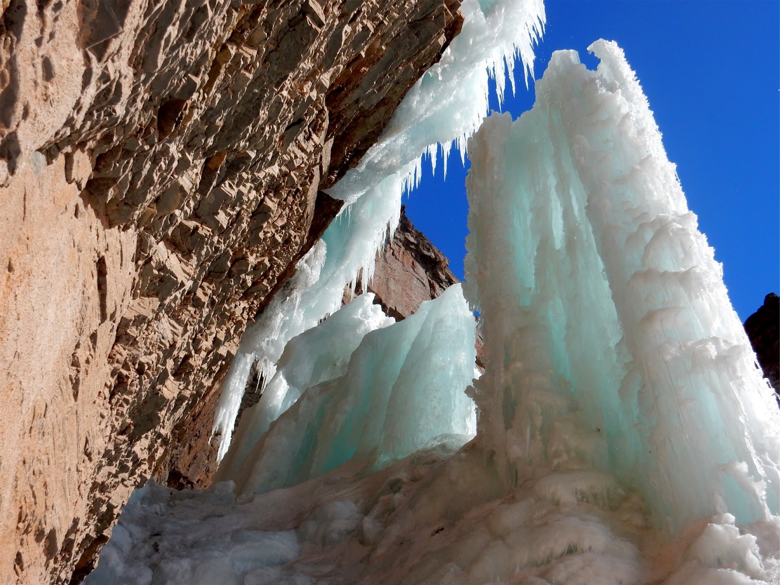
dead end in the distance. There was a
frozen waterfall there. A tall mountain
& ridge line surrounded the waterfall.
I noticed an inukshuk to my left as I neared the dead end. Someone was here before. I set my gear down and cautiously walked up
to the waterfall. There was a large gap
in the middle of the frozen formation and I could hear steady trickles of
water. I was able to walk up to the wall
of rock and photograph what was behind the frozen ice formations. I didn’t dare walk behind the waterfall
because I thought it could collapse at any moment. After photographing the waterfall from
several angles, I ate some more snacks and relaxed in silence.
 |
| Frozen waterfall. |
 |
| Behind the frozen waterfall. |
 |
| Looking up. |
The
silence was short lived because my thoughts were interrupted by a loud squawking
raven. The raven was up high, flying
from one cliff to the next. I’m not sure
why the raven was so annoyed? Or excited? Maybe the bird saw me as an interloper. Eventually, the raven disappeared from view,
but the loud squawks continued for some time.
 |
| Inukshuk |
 |
Following my skidoo tracks to
Strathcona Sound. |
I
placed a small rock on the inukshuk and walked back to my skidoo. I refueled it and started the engine. I followed my skidoo tracks all the way to
Strathcona Sound. I took a picture of
the ice crack I passed before entering the valley. I drove towards the Nanisivik Port Facility
on my way back to Arctic Bay. There was
no one there when I drove by. The summer
construction crews will be arriving in June.
I stayed to the left, driving towards Graveyard Point. The drive took longer than I thought because they
were many snow drifts. It was like driving
around moguls. The snow eventually
smoothed out when I neared Graveyard Point and I followed a skidoo trail to
Victor Bay. I cut across the bay and
found the plowed ice road. I followed it
until the end, then continued along the road to Victor Bay. I was home by 7pm.
 |
| Ice crack. |
 |
| My skidoo in Strathcona Sound, facing west, towards Nanisivik & Arctic Bay. |
My
day excursion was a success. I saw
another corner of Baffin Island and my skidoo didn’t break down. This would be my last solo day excursion
until the fall. I spent the rest of the
long weekend finalizing my final exams.
 |
| Ice road facing south, towards Arctic Bay. |


No comments:
Post a Comment